| Thumbnail |
 |
| Collection |
池田家文庫 |
| Resource Type1 |
古文書 |
| Resource Type2 |
池田家 |
| Category |
寺社学校吉凶仏事 T11 |
| Code |
T11-47 |
| Title |
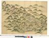
Map of Atsuchiyama (Atsuchiyama zu) |
| Date Wa |
寛政年間 |
| Date Yo |
1789-1801 |
| Description1 |
なし |
| Description2 |
なし |
| Description3 |
なし |
| Zoomify Link |
https://repo.lib.okayama-u.ac.jp/zoomify/T11-47.html |
| Zoomify Flg |
高精細画像あり |
| Rights |
http://www.lib.okayama-u.ac.jp/collections/kicho_tetsuduki.html |
| Description4 |
This map shows the entire area of the Waidani tombs. Slips of paper are attached to indicate the floor areas of tea houses and other buildings. We assume that the map was prepared for a planned visit by the lord of the domain. The verso side of the rightmost end of the map indicates that the map was prepared during the Kansei era (1789–1801). |
