| Description4 |
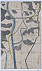
This map, probably a draft for T7-49-1, shows the Kurayasu Canal (also known as the Funadoshi Canal) project. There are two maps of the canal, one for the upper stream of the canal in Oku-Jodo district and the other for the lower stream in Kuchi-Jodo district. This map (T8-56) covers a part of the upstream section from the Yoshii River in Yoshii village to Hirotani village, while T8-107 covers the downstream section from Hirotani village to Hirai village, where the canal converges with the Asahi River. The map shows old and new channels, both designed to supply water to the canal used for water transport. The old channel is drawn in Indian ink, while a new channel, planned to link the old channel, is represented by vermilion. |