| Description4 |
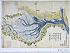
This map of tidelands at Kojima inlet was jointly produced by representatives of Seno-o village in Bicchu province and Kojima district in Bizen province. The map shows many yai (weirs to trap fish at low tide) and landing spaces for boats. Most of the area enclosed by weirs, however, is already filled with sand, particularly the area close to the land. A description is given saying that a survey of water channels has been conducted at two spots. Unfortunately, it is unknown when this map was produced, or in relation to which dispute. The cartographers’ names are specified: Bunjiro, Seigoro, Yaheiji, and Magohachiro. Although it is written that 5 bu (approx. 1.5 cm) on the map corresponds to 100 ken (approx. 180 m), this map is further scaled down because it is either a draft or a copy. |