| Description4 |
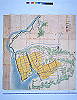
The yellow section on this map represents the new rice fields completed in Kojima. To supply water to the new rice fields, instead of constructing a new channel, as stipulated in the initial plan, the existing water channel, which drew water from Sakane village in Wake district, was extended. At the intersection of the channel with the Sencho River, an underdrain was constructed. This water channel was named “Sakane yosui.” The land area of the new rice fields proved to be about a half the area in the initial plan, with the total rice yield estimated to be more than 10,241 koku. |